
articles
Select Articles

Urban Omnibus, May 2, 2019
What we can see determines what we care about, understand, and take action around. From nineteenth-century scenic paintings to photographs of abandoned cars in New York Harbor, eyes on the Hudson River have built momentum for activism to protect the waterway and the complex ecologies it supports. A vital waterway that New Yorkers have depended on for shipping, food, building materials and recreation, the river has long faced environmental destruction, from industrial pollution to storm surges exacerbated by a changing climate.

New-York Historical Society, April 30, 2019
The champion racing yacht Marietta set sail from Pier A in lower Manhattan on the chilly late morning of September 22, 1897. Mrs. Edith Gifford was aboard along with fellow members of the New Jersey State Federation of Women’s Clubs (NJSFWC) and their male allies from the American Scenic and Historic Preservation Society (ASHPS). This was not a pleasure cruise for the civically-minded passengers: They were hoping to get an up-close view of the destruction of the Palisades.
A longer version of this article was published in the Hudson River Maritime Museum’s Pilot Log, April 2019.

Urban Omnibus, April 10, 2019
New waterfront parks and all manner of development keep bringing New Yorkers closer to the Hudson River, while the threat of storms and sea level rise make life in a river city more perilous than ever. As we’ve extracted value from the Hudson — from the oyster shells ground up to make mortar in the nineteenth century to the scenic views that fuel real estate development today — we’ve changed the environment as well. That idyllic waterway is also a Superfund site, lined with toxic chemicals. The painters of the Hudson River School saw this paradox almost two centuries ago, meditating on the costs of progress on a river that provided an Arcadian escape from life in the modern city at the same time that it was mined for raw materials to build it.

Landscape Architecture Magazine, August 2017
In October 1966, as part of Lady Bird Johnson's campaign to beautify the nation's capital (fig. 1), Lawrence Halprin began working on a set of designs for the Anacostia riverfront in Washington, D.C. Mrs. Johnson’s beautification campaign was an early example of what might be called a green urban renewal program: Instead of wide-scale destruction of urban areas, her efforts aimed to revitalize cities through ecological and aesthetic improvement. Halprin’s designs for Washington’s second river -- which was consistently overshadowed by the Potomac, highly polluted, and surrounded by the city’s poorest and most disenfranchised residents -- were intended to address criticism that the beautification campaign was limited to planting flowers. Plans for the Anacostia riverfront would get back to what Lady Bird Johnson meant by “beautification” all along -- that beauty is a human right that should be accessible to all, and that its power to improve lives and livelihoods should be deployed in the neighborhoods that need it most.

City Lab, The Atlantic, April 26, 2019
In 1866, the historian, journalist, and illustrator Benson Lossing crafted a love letter to the Hudson River. This body of water, running over three hundred miles “from the Wilderness to the Sea,” was unparalleled in “the beauty and magnificence of its scenery, its natural, political, and social history, the agricultural and mineral treasures of its vicinage, the commercial wealth hourly floating upon its bosom, and the relations of its geography and topography to some of the most important events in the history of the Western Hemisphere.” In short, Lossing concluded, the Hudson was “by far the most interesting river in America.”

Urban Omnibus, June 7, 2018
Removal is the basic condition of imprisonment, separating inmates from homes and families. But while people on Rikers Island are held apart from their communities, the fruits of their labor are present throughout New York City’s landscape and economy. Historically, Rikers has served as an environmental laboratory and an agricultural outpost, managing the city’s waste and generating its greenery. The work is practical, but it can also be restorative. For centuries, reformers have held that work in “natural” environments can help rehabilitate those who serve time. Today, solar panels and house-grown food save money for prison administrators nationwide, while preparing inmates to enter “the green economy.” But for many of those sent outside the greenhouse, working in nature is taking ever more dangerous forms, from cleaning up oil spills to fighting wildfires. As prisoners clean and create the landscape, what do their efforts sustain?

Guardian Cities, May 6, 2015
With upwards of 5 million visitors each year, the popularity of New York’s High Line has created difficulties for local residents and small businesses. So is there a better way of introducing nature into our cities?

Guardian Cities, January 16, 2016
Since the term was first coined in 1960s London, gentrification has come to be regarded like a law of nature or scientific fact. How did we come to think about it in this way – and what are the consequences of this perception for our cities?

BBC Radio 3: The Essay, February 18, 2015
In Episode 3, “The Dogon,” Jeanne Haffner discusses a bird's-eye photograph of the Dogon tribe working their fields in Mali, explaining how aerial photography changed the spaces we live in.

ArchitectureBoston, Winter 2009
The widespread practice of visualizing infrastructure is not solely about concrete projects. It is a medium for self-reflection. In the words of the anthropologist Clifford Geertz, one might say that infrastructure is “good to think with.”
Column in Next City, 2010-2011
There’s a study behind every urban planning improvement project. Yet how does one effectively analyze that complex entity we call a “city”? This Street Science column will explore the technological and conceptual devices that planners and others use to do just this.
ArchitectureBoston, Winter 2014
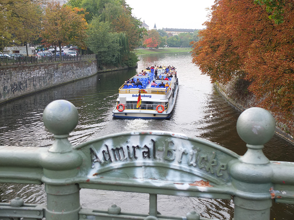
Constructed in the mid-19th century, when Kreuzberg did not even exist, the canal was an answer to the problem of water in Berlin. Formerly a swamp (the word berl meant swamp in 12th-century Polabian Slavic), this landlocked city is surrounded by lakes, and flooding was always an issue…While many industrial canals in other cities have become abandoned wastelands, due to polluted waters and toxic soils, this former drainage ditch continues to make Kreuzberg one of the most sought after places to live.